Last month I was tasked to hold a presentation on the history of 19th century Surabaya; possibly to be extended into the 20th century, if the available sources were too few to allow for a presentation of roughly 30 minutes. As I was working on the presentation, I realized that the turn of the century was not actually a good point to talk about turns in the history of the city. Second, the available sources were not at all too few - but they were too diverse and too different to allow for a continuous narrative.
The reason this post came to be is the third: it's the first presentation where I took notes in prose - not a list - before preparing my slides. The notes highlight different issues and developments in and around late colonial Surabaya and turned out to enough to maybe be helpful to others interested in the city's history. On the other hand, lacking a stringent narrative, they cannot be more than a maybe useful resource.
There are three books, which I've not had the time to read for this. Likely, they hold further information that can add to what I've noted down here. They are:
- Basundoro, P. (2013). Merebut Ruang Kota: Aksi Rakyat Miskin Kota Surabaya, 1900-1960an. Tangerang: Marjin Kiri.
- Cohen, M. I. (2006). The Komedie Stamboel: Popular Theater in Colonial Indonesia, 1891-1903. Ohio University Press.
- Dick, H. (2002). Surabaya; City of Work: A Socioeconomic History, 1900-2000. Ohio University Press.
On a sidenote, the presentation took place in Judith Bosnak's Classical Javanese course, which was most interesting and insightful. I am grateful for having had the opportunity to attend it.
An Afterword for an Introduction
I began working on this presentation with the premise of discussing the history of Surabaya in the 19th century in relation to the beginnings of Indonesian nationalism. A second part was to a take on comparing Surabaya to Batavia.
Hayden White notes that the task of the historian is necessarily that of creating a narrative (White 1990). I came to realize that establishing a continuing narrative on Surabaya over this relatively long time span is impossible with the sources at hand (say, with a relative lack of primary sources and time).
The overall thrust of relevant research changes over time. Relevant available studies discussing the time of the Cultivation System are often general studies of Java at the time and concentrate on rural issues. As Surabaya was a major trading port at the time already, agrarian issues in East Java obviously influenced its developments. Data from these sources could be supplemented by travelers' and traders' reports from the time. At the time, fortifications in Surabaya were build, it was increasingly connected to the rest of Java and exports grew substantially. Maps show that sizable Chinese and Arab settlements were already established at this time, opening the city to the different streams of globalization discussed by Taylor and Ricklefs (Taylor 2012, Ricklefs 2007).
For the years after 1890, a number of studies directly relating to Surabaya are available. A common narrative can be found: new technologies, practices, and ideas enter Surabaya at a fast pace and lead to major reconfigurations in the city's society. Railways, tram, a new harbor, and even an airfield were introduced between 1890 and 1920, connecting Surabaya better with the other major cities and its hinterland. Technical innovations like the telegraph and later the telephone linked Surabaya with Europe; those like the magic lantern, the phonograph, and the movie projector changed the entertainment landscape of the city and brought images and soundbites from Europe and even Africa right into the city.
Inspired largely by a British-Indian innovation, the parsi theater, the Komedie Stamboel developed in Surabaya. And Arab periodicals published in Surabaya were read in the Arab peninsula. Modern ideas about the idea of education lead to the establishment of schools, which subsequently altered power dynamics among the communities and substantially contributed to the nationalist movement(s).
Some of the sources on this period provide background information on the years preceding it, so that at least in terms of time a rather complete image can be provided here following 1830. The aspects discussed for the different times differ largely however.
Geography and Early History
Surabaya is located on the north eastern coast of Java. Right north of it, there is the island of Madura. Built around the Kalimas River, it has access to the Brantas River (the Kalimas is branching of from the Brantas in the Brantas' delta).
Thus, the area is rather flat and was originally relatively swampy. Over the years, the swamps and marshes were recovered to land D'Almeida 1864.
The original harbors were the harbors of Kalimas and Jembatan Merah. The port of Kalimas is a sea port located at the eastern side of the outlet of the Kalimas River, while the port of Jembatan Merah is located closer to the city center and functioned mainly as a river port. (eastjava.com)
Like the Opposite coast it is indented with inlets and bays, and its harbours are considered to be the most protected in Java. (D'Almeida 1864, 93)
Rimmer and Dick note that the city had access to the only natural sea port of the Javanese north coast (Rimmer and Dick 2009) with the harbor of Kalimas.
Timeline
1625 : Surabaya conquered by Mataram
1743 : The VOC takes over control over Surabaya and soon after establishes a Dutch settlement
1835 : Building of Dutch military installations
1875 : Planning of the port of Tanjung Perak by Ir. W. de Jonght
1910 : Finished construction of the port of Tanjung Perak (following plans of Ir. W.B. Van Goor)
1928 : Establishing of the Indonesian Study Club
1942 : Japanese Occupation
1945 : Battle of Surabaya and Indonesian Proclamation of Independence
Reading the Maps
1825
The 1920 map notes this to be infantry barracks.
On this map, one can see the city center. To the west of the Kalimas River, there is the Dutch quarter, presumably with administrative buildings and a large central building. Located to the east of the river, there is the Chinese quarter. In the middle we can see the Jembatan Merah or a predecessor crossing the Kalimas River.
Around the town rice fields and kampongs are visible. At the very top, the port of Kalimas can be found already.
Notable are the also the streets around the city. For example, the street going south (Today Jl. Bubutan) from the city parallel to the Kalimas, which then splits into two - one going south-south-west (Today Jl. Blauran, then Jl. Kedung Doro), one roughly following along the Kalimas towards the south-south-west (Today roughly Jl. Tunjungan, then Jl. Basuki Rahmat). From east to west, there is the Heeren Straat, later Grissersche Weg (Today Jl. Rajawili to the west of the Kalimas, Jl. Kembang Jepun to the east of it). These streets persist until today.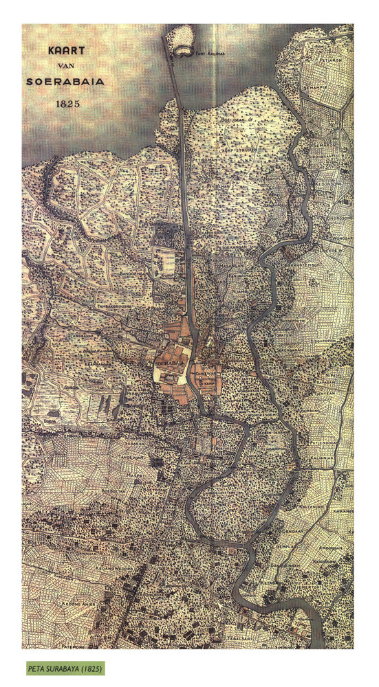
1866
On this map, the city walls (built in the meantime) are very visible. Additional to the Dutch and Chinese quarters, Malay quarters were added north of the Chinese quarters and Arab quarters yet north of these. The Malay quarters were thus located right northeast of Jembatan Merah, say, workers had short ways to walk to the harbor. The Arab quarters were further away from the harbor than any other ethnicity's, while being right south of a newly established Officiers-Kampement and an also newly added citadel. The two streets closest to the Kalimas River could already be found on the previous maps, making it unclear in how far the composition of the quarters was new and planned or naturally developed. Surely however, the quarters were much extended - similar to the rest of the walled city, which grew considerably overall. Notably, the non-European quarters connected the Kalimas with the Kali Pegirian.
Buildings outside walled city also grew in numbers, especially where Kalimas and Kali Pegirian meet in the south.
The port of Kalimas is not visible on this map.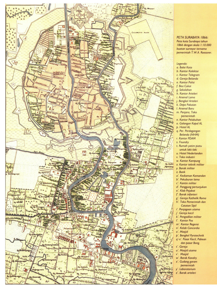
1879
The European quarters within the walled city seem to have shrunk slightly between 1866 and 1872. Some buildings in the northwest of cannot be found in this map anymore. In the northeast of the walled city, a growth of the Malay or Arab quarters can be seen along the Kali Pegirian. Building within the walled city seems to have remained centrally planned, judging from the straight streets.
The district in the south, reaching from the branching of Kalimas and Kali Pegirian almost up to the walled city, saw an immense growth.
The port was upgraded to have a more regular entry, new piers and more houses (likely for storing and administration). Some new settlements can also be found along the Kalimas, between the sea port and the walled city. These buildings are (both judging from the 1879 and the 1900 map) dispersed along the river and can thus likely be identified as dock workers' houses.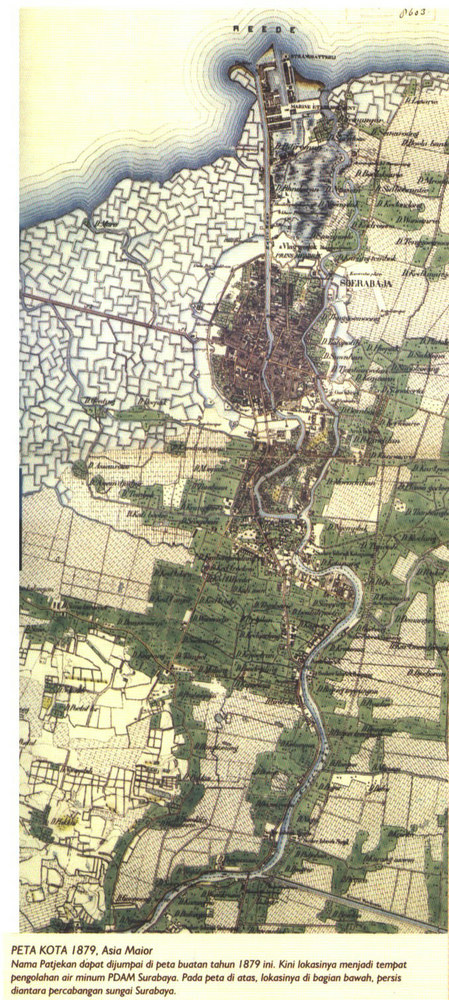
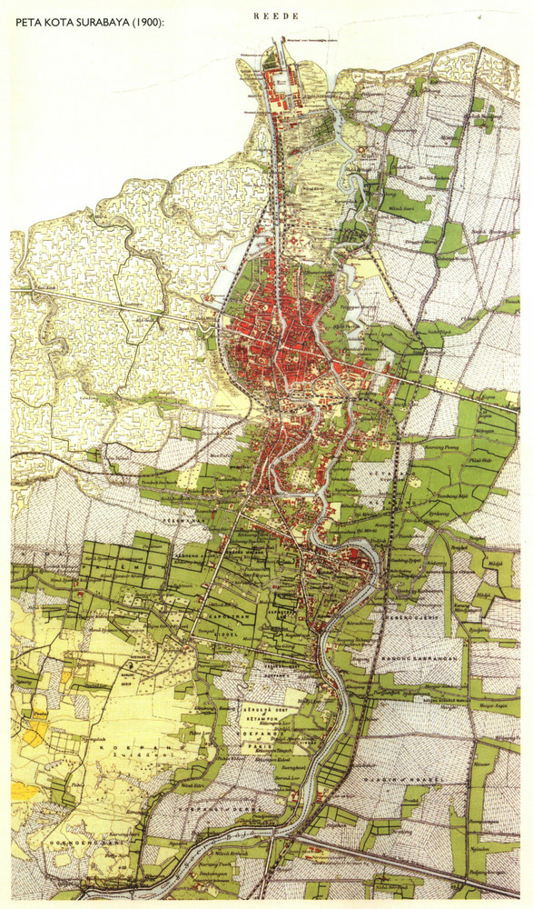
1897 & 1900
In this map, an extension of all the previous trends can be seen. The less planned settlements outside the city center are yet more populated and larger. Along the main east-west road, and towards the east of the previous settlements going south along the Kalimas, new buildings and districts had been built. New was especially the large extension of the city beyond the Kali Pegirian and a whole range of new facilities built at what was the city's southern frontier in 1897, Simpang Road. From 1897 to 1900, the area around these facilities were added.
The city walls seem to have been greatly reduced between 1872 and 1900. While a large unsettled space remained between the walled city and the settlements beyond it, this space was increasingly used for houses. Along the border of the city center, railways were added. From what is now the Stasiun Surabaya Kota, railways went to the sea port in the north, to the west, parallel to the coastline, and - to the east of the Kalimas and the Kali Pegirian - south to Sidoarjo. The Soerabaja N.I.S. Station (Stasiun Surabaya Pasarturi) is also already visible on the map from 1900, although it was not yet opened.
Only minor adjustments to the harbor are visible. The stretch furthest to the right has been extended and a house there has been built. Unfortunately, the corresponding description is not legible (in the 1920 map, the building is noted to be a hospital).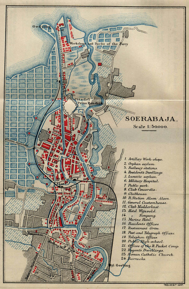
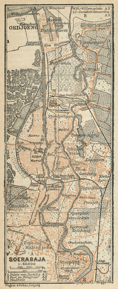
1920
This map shows further extensions of the city. Most notably, streets were straightened and regularized and the former walled city had now merged with the areas south of it, which had greatly grown. Official buildings and other major sites were now distributed almost evenly over the different parts of the city. Along Simpang Road (Today, Jl. Pemuda and Jl. Gubernur Suryo), something akin to a second center had been built in a previously almost undeveloped area developed south of the branching of Kali Pegirian from the Kalimas. In this second center, the Oranje Hotel, the Hotel Sarkies, the Post & Telegraph Office and the Lunatic and Military hospitals could be found. To the north of the City proper, a manufactory is marked, hinting at the extension of the manufacturing sector.
Again, new and less planned areas had been settled further south the Kalimas, repeating the previous pattern.
The railway tracks were further extended from 1900 until 1920, especially those towards the newly build harbor Tanjung Perak, which was completely equipped with an own railway station (Oedjoeng Station). The new harbor featured a large, square basin and was altogether much larger than the previous main sea port Kalimas. To its east, it was directly connected to the Kalimas River, while the opening towards the sea can be found to the west of the harbor.
1935
On this map, the river Kalimas is named Kali Soerabaja before splitting into Kalimas and Kali Pegirian.
The 1935 map again shows the previously describes patterns in terms of the city's extensions. East of the Kalimas, new districts Ngemplak and St. Goeteng have been added. To the south, a new, large district the size of Simpang has been added, Koepang.
The railways have been further extended. Secondary lines have been put around the city center and to the harbor, and the harbor basin is now encircled by railways.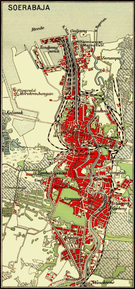
Demography
| City | 1890 | ~1900 | 1920 | 1930 |
|---|---|---|---|---|
| Batavia | 104.590 | 116.000 | 253.818 | 435.184 |
| Surabaya | 117.986 | 147.000 | 192.190 | 341.675 |
Sources: 1890, 1920, 1930: Roosmalen 2008, 35, citing Boomgaard, Peter, A.J. Gooszen, 1991, Changing Economy in Indonesia. A Selection of Statistical Source Material from the Early 19th Century up to 1940. Population Trends 1795-1942, Amsterdam, 220-221. ~1900: Zehden 1906, 372.
For comparison, the overall population number Java might be interesting.Jahr Europäer Chinesen Araber (u. andere Asiaten) Eingeborene (Freie) Eingeborene (Leibeigene) Zusammen 1780 2,029.915 1795 3,559.611 1808 3,730.000 1815 4,615.270 1826 5,403.786 1836 7,861.551 1845 9,530.781 1849 16.409 119.481 27.687 9,420.553 9,584.130 1853 17.417 130.940 27.554 10,104.484 9.650 10,290.045 1854 18.471 129.262 29.209 10,395.510 9.438 10,581.890 1855 18.858 133.655 26.099 10,728.833 8.713 10,916.158 1856 19.431 135.649 24.903 11,105.279 5.188 11,290.450 1857 20.331 138.356 24.615 11,405.596 5.260 11,594.158 1859 20.862 142.582 27.335 11,747.565 5.000 11,943.344
The Colonial Administration
Surabaya was seat to a resident and the center of the Dutch administration of East Java. Some villagers aiming for posts within their local administration went to live in Surabaya to influence higher level administrators there to support their position. (Fernando 1995)
Because of its benefits as a trade center, competition with Batavia existed early on. Governor-General Daendels is reported to have tried to move the colonial capital to Surabaya during his reign, although this plan met with opposition and was eventually abandoned (D'Urville 1837, 136).
Centrally governed administrative powers dwindled however over from the 1820s on. Knight describes how economic power started to move from centrally instituted firms to privately owned ones starting during the time of the cultuurstelsel (Knight 2014a). Similarly, large parts of land in the cities was owned privately and thus removed from immediate government control (Roosmalen 2014).
Urban planning, among other mostly locally relevant issues, remained to be decided in Batavia - by the central colonial government - until 1903. Only after the Decentralization Act of that year were "local councils, independent entities with their own administrative and financial responsibilities" (Roosmalen 2014, 88) created. These local councils were in turn not allowed to carry out their projects (ranging from street restructuring to water and sewerage) work on private land (including desa lands) until a further regulation from 1918. Altogether, urban planning in the Dutch East Indies developed from creating racially divided quarters to more integrated concepts. The concept of a racially divided town also distinguished kampongs (be they adjacent to the colonial city or not) from the European-planned city itself, although the distinction did not necessarily work within the city itself either (Roosmalen 2014, Colombijn and Coté 2014).
The local councils (later renamed to municipal councils) slowly extended their powers through a common organization, the Decentralization Congress, with meetings held in Bandung, Batavia, Malang, Semarang, and Surabaya (Roosmalen 2014, 93).
Religion
1870, there were reportedly 10820 santri in Surabaya, relatively much less than, say, in Semarang, where there were 17877 according to the same count (Fernando 1999). The areas south of it were nevertheless highly attractive for santri, and in Surabaya, too, many pesantrén were to be found. (Fernando 1999, Fernando 1995)
In line with the attractivity for santri overall, but also following general, colony-wide trends, the number of hajis rose rapidly 3110 in 1874. (Waal 1876, 246)
As the city was split into racially identified quarters in the 19th century, important ceremonial places like graveyards were located accordingly (Husain 2014, 327).
The city is remarkable also as a center of the Arab community. Although the Arab community remained relatively small (Bloembergen (2007, 125) notes roughly 2,600 Arab inhabitants in Surabaya between 1900-1920), Surabaya was one of the few places in which Arabs - mostly from Hadramawt in what is now Yemen - settled down. An Arab newspaper was established in 1917, an Arab school in the previous years (Mobini-Kesheh 1996).
Going Out and Having Fun: Arts and Entertainment in Surabaya
Archibald probably chose Surabaya for his first phonograph demonstration in the Indies because it was the largest and most prominent city of the colony at the time and because urban entertainment was increasingly evident there. (Suryadi 2006, 277)
A thorough discussion of theater and arts in Surabaya in the period before the last decade of the 19th century has so far been not available to me. A short summary of Cohen's discussion (Cohen 2001, 325-327) of it may suffice: The different ethnic and racial groups organized mainly race-specific performances (wayang kulit, wayang krucil and tandakan performances in the case of Javanese; Chinese organized both Chinese opera performances and wayang topeng and wayang kulit ones). Different from the other major cities, European festivities were also joined in by other groups.
In the last decade of the 19th century, Surabaya was the place were the komedie stamboel developed (Originating as the name of a single group of performers, the term was later used as a general genre name). Komedie Stamboel has garnered a sizable amount of attention, being hailed as a landmark development, if not the beginning of modern, commercial theater in Java. Among other things, racial considerations served its fame: inspired largely by a British-Indian form of theater, the parsi theater, Indo-European and European actors played localized stories from different regions (the standard repertoire being the stories of the 1001 Nights, but classical European stories were also adapted and played). Held in Malay, the performances originally attracted mainly Chinese audiences, but the audience soon became much more diverse. Especially important for this presentation are two aspects of the Komedie Stamboel: Cohen notes that the Komedie Stamboel, especially in its use of female Indo-European and European actresses, served to reformulate racial hierarchies in colonial society into gendered hierarchies, in which male Chinese and 'native' viewers were positioned above the European actresses. Second, he notes that similar developments were prevented in Batavia by the much more restrictive administration there. (Cohen 2001)
Forms of arts and entertainment based on the introduction of new technology followed soon after. Mostly originating in Europe, Surabaya was a prime location for their introduction, as detailed in the beginning quote of this section. (Suryadi 2006)
Surya Suryadi (2006, fn. 82) mentions both European and Chinese performers, who seem to have been rather well connected along professional lines.
Starting sometime around the 1870s, early phonographs were exhibited in Dutch East Indies by traveling performers, who also exhibited other technical innovations like the magic lantern (and who, given the city's importance by that time, often also visited Surabaya). By 1892, the first exhibitions featuring the Edison phonograph, by performers doing international tours, took place - the local performers soon after got their own machines and started doing local tours with them. Again, the first recordings to be played were European upper-class music and a recording of the British Prime Minister of the time, William E. Gladstone, but as the machine could both record and play, recordings of local soundscapes were soon created. (Suryadi 2006)
Following an exhibition, of moving pictures in 1897, the city developed into a central place for cinemas - according to Dafna Ruppin well comparable to the major Western cities and with only a slight delay. As moving pictures technologies developed in Europe, most films shown happened to be European, but from the beginning local recordings were also shown. Also, from the beginning moving pictures were made available across class lines. Taking place in established theaters, the first shows adjusted prices to the regular audiences, so that even poorer people had early access. Soon after, moving pictures exhibitions moved into designated venues (first tents, later houses), which were used by the different groups collectively. Accordingly, new forms of racial and class differentiation were developed (interestingly, Ruppin notes, seating 'natives' behind the screen bears parallels to wayang kulit; Ruppin 2014).
These developments paralleled an increasing differentiation in terms of the venues people visited. Europeans increasingly frequented class-based clubs (Ruppin 2014).
Military and Police
Different sources report on military expeditions from Surabaya. Similarly, Surabaya was used as a safe place in case of uprisings.
1904 : "European women and children sent to Surabaya by train" (Fernando 1995) to evade peasant uprising in Mojokerto.
1907 : Defeat of a purported peasant uprising in Kediri with support by the Dutch military arriving from Surabaya (Fernando 1999)
The military was composed of both Asian and European soldiers, whereas the police was almost entirely Javanese (D'Almeida1864, Bloembergen 2007). The above-mentioned riots, together with an increasing blurring of the racial segregation in the city (more and more people considered 'European' were living in the kampongs, while rich Asians increasingly lived in the European quarters) and the arrival more and more Europeans inexperienced with Java, including many women, led to an increased feeling of insecurity among the European population and eventually resulted in the planning and implementation of police reform for the major cities (in the beginning Batavia, Semarang, and Surabaya) in 1911-1914, although such a reform had been discussed since at least the 1870s. Surabaya was to be used as a primary testing ground for the modernized police (The narrative of a 'civilized' and 'modern' police force figured prominently in the debate surrounding the reform).
Whereas policing was previously organized in a race-segregated manner and oftentimes extremely violent, the new police force was to serve the whole city across race lines and was organized following the example of contemporary European police (for a rather extensive discussion of the pre-reform police organization, see Bloembergen, 2007, 127-129). Racial biases were however apparent in the staff of the new police force: the highest posts were filled by Europeans, while the vast majority of the police force was Javanese (Bloembergen 2007).
Alternative, competing, and privately organized police forces existed until the end of the colonial era however. Bloembergen notes that the Sarekat Islam set up its own kampong police in the early 1910s, which was often more trusted by the local inhabitants than the colonial police. Similarly, the military helped out and competed with the police at times (Bloembergen 2007).
Military Facilities
Fortifications in the city were built in the 1830s using forced labor. The previous settlement was destroyed for the building of the military installations (Chandra and Vogelsang 1999, Ruppin 2014, 889). Industry for the production of military goods - e.g. cannon bullets - grew soon after.
Interesting to note is the building of an economy around the military facilities, somewhat resembling similar developments in the 20th century in other parts of Southeast Asia:
Outside the gates were a number of Javanese women, waiting to charm the poor soldier with their wiles and graces, and rob him of his wretched pittance. The women of doubtful character seen within and without the Dutch forts are a disgrace to the otherwise well-regulated system of Dutch military Government. (D'Almeida 1864, 101)
Economy and Infrastructure
Harbor City
Surabaya is regularly cited as the largest and most active port city of the Dutch East Indies in the 19th century.
Up until its end, the VOC's ships were obligued to stop over in Batavia, which gave the port a competitive edge in the 17th and 18th centuries (Bruijn 1980). These restrictions to Dutch trade seem to not have persisted under direct Dutch rule of Java. Surabaya on the other hand featured a natural sea port, that was safer to use than Batavia's port, which "was an offshore anchorage exposed to the west monsoons [and] had no navigable waterways to the interior, and only a narrow coastal hinterland" (Rimmer and Dick 2009), while Surabaya's port Kalimas directly linked trade with the relatively larger hinterland via the river of the same name (Different travel and trade reports from the time confirm this. See: Scherzer, 1965, 2).
By the early 20th century, direct trade had been established between Surabaya and European harbors (Zehden 1906).
While Surabaya was thus better equipped, it could stay on par or even ahead of Batavia during the 19th century, while Batavia remained the administrative center of the colony. With the establishment of the port of Tanjung Priok in Batavia, Surabaya however lost its relative advantage in terms of port accessibility and safety. The establishment of better railway links to the uplands around Batavia also gave it better access to its hinterland (Rimmer and Dick 2009, 98).
After the VOC's decline, administration was however slightly decentralized. Foreign trade had to go via any of the ports of Batavia, Palembang, or Surabaya to receive an official stamp of approval by the colonial customs office (Allgemeine preussische Staats-Zeitung 1842, 239).
By 1864 a dock existed for ships to be repaired in Surabaya (D'Almeida 1864), rather than in Singapore. Zehden, at the beginning of the early 20th century, points out that the establishment of the docks in Surabaya was notable for of the Dutch East Indies, and that Surabaya "had the best roadstead in Java" ("Surabaya 147.000 Einw., hat die beste Reede in Java". P. 372; my translation; Zehden 1906, 23, 372).
Trade was further strengthened by the establishment of a Chamber of Commerce in Surabaya in 1864 (Chambers of Commerce were created at the same time in Batavia, Semarang, Makassar, and Padang). The Chamber of Commerce was set up by the colonial administration and restricted to have only seven appointed members (Knight 2014a, 322).
Agriculture and Industry
Export-Oriented Agriculture
In the early 19th century, the area around Surabaya was already focused on export-oriented agriculture. D'Urville reports seeing many coffee plantations in the region, while rice fields were to be found more on Madura (D'Urville 1837, 140).
Rice was also exported via Surabaya, although the harvesting of rice for export further declined over the course of the 19th century. In the Allgemeine preußische Staats-Zeitung of 1842, it is reported how the first Opium War came to the detriment of Surabaya as a port city, as rice exports to China declined because of it (Allgemeine preussische Staats-Zeitung 1842, 373). Other target markets for East Javanese rice were primarily located in other Asian regions, including the Middle East (Knight 2014a, 320).
Different from West Java, coffee played a relatively minor role as an export crop in Surabaya residency. Sugar became relatively dominant in the 1840s: The "Kultuurverslag" of 1850 is cited for reporting 24 percent of the population being engaged in sugar cultivation on 4% of the available land (Fasseur 1992, 87, also 34).
Within the residency of Surabaya, peanut became an import secondary crop after 1890. It rose from 29 percent to 56 percent of the harvested secondary crops between 1890 and 1895 (Fernando 1995.
Rice Prices
In the 1850s, units for agricultural projects differed per major port city. Thus, at least rice was considerably cheaper in Surabaya than in Semarang or Batavia:
Für Reiss, Getreide und Salz gilt der Koyang = 27 Piculs, = 3662,04 engl. Pfd. = 1661,06 Kilogrammen, = 2966,12 Wiener Pfund. In Samarang ist 1 Koyang = 28, in Surabaya = 30 Piculs. Scherzer 1865, 51 (Van Zanden (2004, 1032) gives the same numbers, without however referring to a primary source.)
Even for a larger koyang, the prices as listed in colonial reports were comparatively lower in the years between 1840-1846, although the regional prices fluctuated strongly. Price fluctuations were considerable both over the years and within the year, as prices surged before a new harvest period (Zanden 2004). Fasseur cites Baud to the King, V 18 Febrary 1847, no. 9, Kol. 1765 as follows for average rice prices per koyang in guilders:Year Batavia Semarang Surabaya 1831 114 69 85 1832 141 73 107 1833 125 114 134 1834 145 125 149 1835 140 119 127 1836 123 111 139 1837 100 105 122 1838 110 94 105 1839 144 121 132 1840 131 122 122 1841 129 129 107 1842 143 130 119 1843 132 101 105 1844 142 141 129 1845 162 208 186 1846 155 148 134
The Manufacturing Sector
A small manufacturing industry developed in Surabaya in the end of the 19th century (see above). More manufacturing was however concentrated in Batavia (Rimmer and Dick 2009, 98).
Communication Infrastructure
With the introduction of modern telecommunications technology to the colony, Surabaya was one of the first cities to have access to these. The telegraph was introduced in the 1860s and reached Java long before it was connected through cables: steam ships carried messages from Sri Langka (later Singapore) to Batavia. Batavia was connected by cable in 1870 (Knight 2014a, 319). The source does not state when Surabaya was connected, but it appears unlikely that a similar development would not have taken place.
The telephone reached Surabaya in 1884; telephone lines to Batavia were established in 1897. By 1906 at the latest, Semarang could be reached using the phone, too (Ruppin 2014, Zehden 1906, 372).
Transportation Infrastructure Beyond the Harbor
Surabaya was one of the main stops along Daendels' De Grote Postweg and thus connected with a relatively easily passable road to Batavia and Surakarta. Other major road-building projects to connect the cities followed until about the 1890s, whereas later developments projects focused on the upgrading of roads to contemporary standards (Khusyairi and Colombijn 2014, 254).
Railways were used in Surabaya starting in 1878, with a line connecting Surabaya with Pasuruan and soon after Malang. In the 1890s, lines connecting it with Bandung, Yogyakarta and Batavia were opened. Remarkably, there were two competing companies offering railway services in Surabaya: The Staatsspoorwegen and the Nederlands-Indische Spoorwegmaatschappij (NIS). Their two main stations, Kota and Pasar Turi respectively, were not directly linked, so that passengers had to use dokar and taxis to travel between them.Trams followed from around 1890 on, with an increasing number of tram lines being added over the years until the end of the colonial era by the 1920s, these trams dominated public transport in the city: 11.400.000 passengers used the electric tram in the year 1927, 5.200.000 the steam tram.
Railways on the other hand also changed the transportation of freight. Soon after their introduction, they had largely replaced river traffic for the transportation of export goods and other bulkier items. Transport of smaller items followed when railways companies lowered prices. (Dick 2000)
Howard Dick names 700 tonnes of daily river transport of sugar cane into Surabaya as compared to seasonal daily averages of about 6,000 tonnes in the case of transport by railways for the year 1903.
Airplanes also started to become available in the early 20th century. The first flight from Surabaya took place in 1911, and by 1929 regular flights took place from Surabaya to Batavia, Bandung, and Semarang. The location of the airfield was often regularly. (Khusyairi and Colombijn 2014, 261)
Alternative means of public transport took place using carts and carriages and omnibuses (Dick 2000, Khusyairi and Colombijn 2014).
From 1890 onward, cars (and consequently also taxis) started to become an increasingly common means of transportation. "By 1911 about 500 cars had been registered, by 1920 this number had risen to 2,000 and in 1939 there were 6,657 cars, including 466 taxis. Another source records that there were over 3,400 registered cars in 1927" (Khusyairi and Colombijn 2014, 255, citing Howard Dick's City of Labour and the Official Statistics of 1928).
The bicycle was a yet more common means of personal transportation. Available to a wider range of people because of cheap Japanese-produced bikes, there were about 36,000 bicycles in Surabaya by the end of the colonial era. Especially during the depression following the 1928 financial crisis, their popularity surged (Khusyairi and Colombijn 2014).
Racial and class divisions between the districts were also reflected in the access to different means of transportation. As Khusyairi and Colombijn posit, the NIS railway lines and older steam trams connected Surabaya's hinterland and the kampongs in the city's west with the port, while a more modern electric tram connected the rich inner city districts in the first half of the 20th century (Khusyairi and Colombijn 2014). Obviously, direct personal access to private means of transportation, e.g. the car, was also dependent on class (and thus in many cases race). The same authors consequently posit that the confrontation with more and more different also lead to an everyday confrontation with class and racial discrimination and fostered anti-colonial resistance.
Financial Services and Business
In 1828, the Javasche Bank was founded (Scherzer 1865, 51), which operated a branch in Surabaya from 1829 on. After this, a number of other large Dutch-owned banks opened. Access to these banks was restricted to "the most wealthy and creditworthy merchants" (Zanden 2004, 1046), both of European descent and others. Whereas it was mainly Chinese merchants who used the low interest rates of these banks to lend on the money to peasants (at higher interest rates), both Chinese and Europeans used them to build private enterprises engaging in trade primarily with other areas in Asia up to the 1880s (Knight 2014a, Zanden 2004).
Knight also notes that the different groups worked - at least at times - closely together: "The big Surabaya merchant and 'entrepreneur' [...] J.E. Banck, for example, could hardly have made his way in the world to the extent that he did [...] without the backing of leading Chinese Indonesian capitalists active in East Java" (Knight 2014a, 317).
Surabaya as a Place for the Nationalist Movement
Surabaya was home to one central group of the nationalist movement from the 1910s onward, the other most major cities being Bandung - then base of Sukarno - and Batavia -led mainly by Sartono (Ingleson 2008).
The first public meeting of the Sarekat Islam was held in Surabaya in 1913 (Bloembergen 2007).
In 1928, the Indonesian Study Club was founded. It acted as a forum for meetings between different East Java-based nationalist leaders. Members of the Indonesian Study Club founded a number of labor unions based on the idea that to be effective, they needed to offer mutual aid programs (e.g. legal help or financial help in the case of unemployment or death). In line with this, even a bank - named "Indonesian National Bank" - was founded. Notably, the Surabaya-based nationalists argued for relatively low-key strategies to avoid repression. Labor unions were, e.g. to not be linked with political parties (Ingleson2008).
Appendix
Notes on Sources
Useful sources for illustrations were:
- The Surabaya Memory page of the digitized collections of the Petra Christian University
- Maps from the Perry-Castañeda Library Map Collection of the Libraries of The University of Texas, Austin
- Maps and travelogues are also numerous on the site of the Southeast Asian Visions project (Cornell U.)
Additional Tables
| Kind of vehicle | Number of vehicles | Number of vehicles per 1,000 persons |
|---|---|---|
| Private cars | 3,435 | 13.6 |
| Buses | 102 | 0.4 |
| Trucks | 387 | 1.5 |
| Motorcycles | 610 | 2.4 |
| Bicycles | 22,360 | 88.4 |
| Kosong | 165 | 0.7 |
| Dokar & Keretek | 1,952 | 7.7 |
| Pushcarts | 610 | 2.4 |
The presentation is now uploaded, too. It can be found here.
References
- Bloembergen, Marieke. 2007. “The Dirty Work Of Empire: Modern Policing And Public Order In Surabaya, 1911-1919”. Indonesia 83: 119-150.
- Bruijn, Jaap R. 1980. “Between Batavia And The Cape: Shipping Patterns Of The Dutch East India Company”. Journal Of Southeast Asian Studies 11 (2): 251-265.
- Chandra, Siddharth, and Timothy J. Vogelsang. 1999. “Change And Involution In Sugar Production In Cultivation-System Java, 1840-1870”. The Journal Of Economic History 59 (4): 885-911.
- Cohen, Matthew Isaac. 2001. “On The Origin Of The Komedie Stamboel Popular Culture, Colonial Society, And The Parsi Theatre Movement”. Bijdragen Tot De Taal-, Land- En Volkenkunde 157 (2): 313-357.
- Colombijn, Freek, and Joost Coté. 2014. “Modernization Of The Indonesian City, 1920–1960 ”. Edited by Freek Colombijn and Joost Coté.
- Cribb, Robert B., and Audrey Kahin. 2012. Kamus Sejarah Indonesia. Depok: Komunitas Bambu.
- D'Almeida, William Barrington. 1864. Life In Java: With Sketches Of The Javanese; In Two Volumes: Vol. 1. London: Hurst and Blackett.
- Dick, Howard. 2000. “Representations Of Development In 19Th And 20Th Century Indonesia: A Transport History Perspective”. Bulletin Of Indonesian Economic Studies 36 (1): 185-207.
- D'Urville, Jules-Sébastien-César Dumont. 1837. Malerische Reise Um Die Welt: Eine Geordnete Zusammenstellung Des Wissenswerthesten Von Den Entdeckungsreisen Eines Magellan, Tasman ... Baumgärtner.
- Fasseur, Cornelis. 1992. The Politics Of Colonial Exploitation: Java, The Dutch, And The Cultivation System (Studies On Southeast Asia). Ithaca, NY: Southeast Asia Program, Cornell Univ.
- Fernando, M. R. 1995. “The Trumpet Shall Sound For Rich Peasants: Kasan Mukmin's Uprising In Gedangan, East Java, 1904”. Journal Of Southeast Asian Studies 26 (2): 242-262.
- Fernando, Radin. 1999. “In The Eyes Of The Beholder: Discourses Of A Peasant Riot In Java”. Journal Of Southeast Asian Studies 30 (2): 263-285.
- Husain, Sarkawi B. 2014. “Chinese Cemeteries As A Symbol Of Sacred Space: Control, Conflict, And Negotiation In Surabaya”. Edited by Freek Colombijn and Joost Coté.
- Ingleson, John. 2008. “Sutomo, The Indonesian Study Club And Organised Labour In Late Colonial Surabaya”. Journal Of Southeast Asian Studies 39 (1): 31-57.
- Khusyairi, Johny A., and Freek Colombijn. 2014. “Moving At A Different Velocity: The Modernization Of Transportation And Social Differentiation In Surabaya In The 1920S”. Edited by Freek Colombijn and Joost Coté.
- Knight, Roger. 2014. “Rescued From The Myths Of Time: Toward A Reappraisal Of European Mercantile Houses In Mid-Nineteenth Century Java,C. 1830-1870”. Bijdragen Tot De Taal-, Land- En Volkenkunde 170 (2/3): 313-341.
- Mobini-Kesheh, Natalie. 1996. “The Arab Periodicals Of The Netherlands East Indies, 1914-1942”. Bijdragen Tot De Taal-, Land- En Volkenkunde 152 (2): 236-256.
- Ricklefs, M. C. 2007. Polarizing Javanese Society: Islamic And Other Visions (C. 1830-1930). University of Hawaii Press.
- Rimmer, Peter J., and Howard Dick. 2009. The City In Southeast Asia: Patterns, Processes And Policy. Singapore: NUS Press.
- Roosmalen, P.K.M. van. 2008. “Ontwerpen Aan De Stad: Stedenbouw In Nederlands-Indië En Indonesië (1905-1950)”. https://repository.tudelft.nl/islandora/object/uuid:40d1eef6-56fb-49a2-b5ad-4afbbef8a121?collection=research.
- Roosmalen, Pauline K.M. van. 2014. “Netherlands Indies Town Planning: An Agent Of Modernization (1905–1957)”. Edited by Freek Colombijn and Joost Coté.
- Ruppin, Dafna. 2014. “From "Crocodile City" To “Ville Lumière”: Cinema Spaces On The Urban Landscape Of Colonial Surabaya”. Sojourn: Journal Of Social Issues In Southeast Asia 29 (1): 1-30. doi:10.1355/sj29-1a.
- Scherzer, Karl von. 1865. Reise Der Österreichischen Fregatte Novara Um Die Erde: In Den Jahren 1857, 1858, 1859; Zweiter Band. Wien: Carl Gerold's Sohn, Wien, 1865.
- Suryadi, Surya. 2006. “The 'Talking Machine' Comes To The Dutch East Indies: The Arrival Of Western Media Technology In Southeast Asia”. Bijdragen Tot De Taal-, Land- En Volkenkunde 162 (2/3): 269-305. doi:10.1163/22134379-90003668.
- Taylor, Jean Gelman. 2012. “Colonialism: Agent Of Modern Globalization”.
- Waal, E. de. 1876. Onze Indische Financien: Nieuwe Reeks Aanteekeningen. Nijhoff. https://books.google.de/books?id=tXdpAAAAcAAJ.
- White, Hayden V. 1990. Die Bedeutung Der Form: Erzählstrukturen In Der Geschichtsschreibung. Frankfurt am Main: Fischer-Taschenbuch-Verl.
- Zehden, Karl. 1906. Handelsgeographie Auf Grundlage Der Neuesten Forschungen Und Ergebnisse Der Statistik. K.U.K. Hof- und Universitätsbuchhändler.
- “Allgemeine Preußische Staats-Zeitung: 1842, 1 - 6”. 1842.
